Much has been written about Machu Picchu since its rediscovery in 1911 by Hiram Bingham and his expedition crew. And although I was truly amazed at the ruins of Machu Picchu when I hiked around it a few months ago, I was mesmerized by the area geology as soon as I got off the train…
Peru’s Sacred Valley- Andean Culture With Some Geologic Context
Most people traverse Peru’s Sacred Valley quickly on their way from Cusco to Machu Picchu. But this stretch of countryside is an area well worth staying around in for awhile, both for getting to know Andean culture and understanding some of its history. The Sacred Valley is considered the heartland of the Inca Empire (1438…
Wildlands Wildfire – Getting Ready for the Fire Season at the McCall, Idaho Smokejumper Base
The McCall Smokejumper Base, in west-central Idaho, has 70 wildland firefighters on staff. McCall’s Smokejumper program was established in 1943, and since then has continually provided fire management personnel to wildland fires throughout the nation. As noted on the McCall Smokejumper website: “Today, the McCall Smokejumper Unit is an interagency resource providing highly trained, experienced…
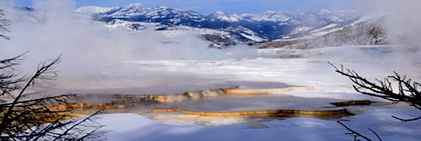
Cusco, Peru – Markets, Ruins, and a Geologic Puzzle
During the 14th century, the Inca ruler Inca Pachacuteq (Tito Cusi Inca Yupanqui) transformed the central Andean area of present-day Cusco, Peru into a major urban center. The city became the capital of the Inca empire, containing religious and administrative areas that were surrounded by fertile agricultural expanses. In the 16th century, the Spanish conquered…
Spiralling Global Temperatures
This is one of the best visualizations for global temperature change that I’ve seen. It’s created by Ed Hawkins, a climate scientist in the National Centre for Atmospheric Science at the University of Reading. As noted by Ed Hawkins: “The animated spiral presents global temperature change in a visually appealing and straightforward way. The pace of…
Lima, Peru’s Historic Centre – A UNESCO World Heritage Site and the Earth-Shattering Events That Helped Shape It
Lima, Peru is fast becoming a preeminent food hotspot with traditional Peruvian foods and various fusion cuisines that I found extremely delicious. And of course it is also internationally known for extraordinarily magnificent museums such as the Museo Larco with its collection of pre-Columbian art. Lima, the capital city of Peru, has a population of almost…
The Miraflores District of Lima, Peru – Green Spaces, Alluvial Fans, and Huaca Pucllana
I just returned from travels in Peru, which took me from Lima to Cusco, to the Sacred Valley, and eventually to Machu Picchu. It was a spectacular trip! Adventure Life, a company from Missoula, Montana, did the trip travel logistics for our group of University of Montana Alumni. They did an amazing job, starting with…
Ice Melt, Sea Level Rise, and Superstorms
Dr. James Hansen (Director of Climate Science, Awareness and Solutions Program Earth Institute, Columbia University) and 18 co-authors just published an article – Ice melt, sea level rise and superstorms: evidence from paleoclimate data, climate modeling, and modern observations that 2 °C global warming could be dangerous – in the journal Atmospheric Chemistry & Physics. Their article is…
Forest Legacy Lands – Preserving Forests in Northwestern Montana
Montana Outdoors just published an article on two Forest Legacy projects that I’m very proud to have worked on – the Haskill Basin and Trumbull Creek projects, which are both located near Whitefish, MT. Both are projects where varied interests have come together for a common goal. As well stated by the article’s author, Allen…
Siccar Point – The Roots of Modern Geology
Siccar Point, located on the southeast coast of Scotland, is well revered in the geological community. Outcrops at this locale display ‘Hutton’s Unconformity’. This is an angular unconformity where tilted rock units of about 370 million years in age called the Old Red Sandstone (with a basal layer of conglomerate) lie atop nearly vertical strata of greywacke that…
Puerto Rico – Beaches, Rain Forests, Bio-Bays, and Rocks
Spending time in Puerto Rico is a fantastic experience. The beaches are wonderful, the rain forest of El Yunque National Forest is unique in the U.S. Forest Service’s holdings, the bio-bays are enchanting, and of course there are intriguing rocks that underlie all these natural wonders. Geologic Setting Puerto Rico is the eastern-most island of…
A High-Elevation Eocene Fossil Vertebrate Site in the Elkhorn Mountains, Southwestern Montana
The Dog Town Mine Tertiary fossil vertebrate locality is nestled on private property within the southern extent of the Elkhorn Mountains, southwestern Montana. The locality is about 20 miles southwest of Townsend, Montana, where Mesozoic and Paleozoic carbonate, quartzite, and red-colored mudstone, siltstone, and sandstone rocks underlie Eocene (Chadronian) strata. These unconformable Eocene strata contain…
Earl Douglass and the Tertiary Geology of Southwest Montana’s Madison Bluffs
Most vertebrate paleontologists probably think of the spectacular dinosaur finds near Jensen, Utah, when the name Earl Douglass is mentioned. Douglass’s discovery of a partial Apatosaurus near Jensen in 1909 did spark the beginning of his long career with finding more dinosaur material in what we now know as Dinosaur National Monument. But Douglass began his quest for…
Iceberg Lake Glacier, Glacier National Park – Hiking Through A Changing Landscape
Iceberg Lake is situated in the Many Glacier area of Glacier National Park. The hike is about a 10 mile round trip and gains about 1275 feet in elevation. The trail winds through prime grizzly bear habitat, so be sure to hike with a group, make lots of noise, and carry bear spray. It would…
A Different Look At The Burgess Shale – The Stanley Glacier Burgess Shale Hike, Kootenay National Park, British Columbia, Canada
The Middle Cambrian Burgess Shale and its contained fossils are legendary to earth scientists. These fossils are by far the best record of Cambrian animal fossils. The importance of the Burgess Shale fossils is also linked to their excellent preservation. The fossils include many soft bodied animals in addition to those with hard parts –…