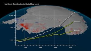
A new study published in Science on 11/30/2012 shows that the Antarctic and Greenland ice sheets are losing more than three times as much ice each year as they were in the 1990s. The melting of ice, two thirds of which has occurred in Greenland, has raised sea levels by 11.1 millimeters since 1992.

Based on the Shepherd et.al. Science study, this image of Antarctica has a superimposed chart of changes in global sea level due to ice sheet melting since 1992. The background image shows thickening (blue) and thinning (red) of Antarctica’s ice sheets over the same period.
The study is the combined work of 47 researchers from 26 laboratories and was supported by the European Space Agency and the National Aeronautics and Space Administration. As summarized in the abstract of the Science publication, “We combined an ensemble of satellite altimetry, interferometry, and gravimetry data sets using common geographical regions, time intervals, and models of surface mass balance and glacial isostatic adjustment to estimate the mass balance of Earth’s polar ice sheets. We find that there is good agreement between different satellite methods—especially in Greenland and West Antarctica—and that combining satellite data sets leads to greater certainty. Between 1992 and 2011, the ice sheets of Greenland, East Antarctica, West Antarctica, and the Antarctic Peninsula changed in mass by –142 ± 49, +14 ± 43, –65 ± 26, and –20 ± 14 gigatonnes year−1, respectively. Since 1992, the polar ice sheets have contributed, on average, 0.59 ± 0.20 millimeter year−1 to the rate of global sea-level rise.”
The research was undertaken as part of the Ice Sheet Mass Balance Inter-comparison Exercise (IMBIE). Read more on the study: Science – A Reconciled Estimate of Ice-Sheet Mass Balance
